AI-Based Nowcasting Projects
The Leeds Nowcasting Collective (LNC) brings together researchers working on machine learning and AI methods for environmental prediction and nowcasting applications. These projects explore approaches including deep learning, diffusion models, object-based methods, satellite-based prediction, and probabilistic forecasting for environmental hazards. This page highlights research projects and experimental systems developed within the group.
DustCast — Image-Based Nowcasting of Dust and Convective Storms (Hermes et al., 2025)
DustCast is a generative nowcast model for predicting dust and convective storms in West Africa. It is based on a diffusion model and forward predicts false-colour satellite images that highlight dust and deep convective clouds. This imagery is commonly used by forecasters to track dust storms and convective storms. A forward prediction of this product can easily be integrated into the forecasting workflow. DustCast provides both deterministic and ensemble nowcasts and can output probabilistic nowcasts for dust and deep clouds. It has been shown to produce skilful nowcasts up to 4 hours lead time. DustCast is the first model of its kind for nowcasting dust and helps forecasters to improve predictions of extreme weather that currently operational numerical weather prediction models do not reliably reproduce.
Publication: https://doi.org/10.1016/j.wace.2025.100828

Observed images of the false-colour composite for desert dust and predicted images from a nowcast initialised at 07/06/2024 17 UTC. The top left shows the latest observation that was fed into the model and observations for the following hours. The bottom row shows the corresponding predicted frames. Pink colours indicate dust, dark red colours indicate deep clouds.
SII-NowNet — Simple Initiation and Intensification Nowcasting neural Network (Smith et al., 2026)
SII-NowNet is a machine-learning-based nowcasting system designed for predicting the initiation and intensification of convective storms across the Tropics using geostationary satellite brightness temperature observations. The framework is based on a U-Net architecture and uses two consecutive satellite infrared images as input to generate probabilistic nowcasts of convection development up to six hours ahead. By relying solely on freely available satellite data, SII-NowNet is designed to be easily transferable across tropical regions, including areas with limited observational infrastructure.
Publication: https://doi.org/10.1175/AIES-D-25-0043.1
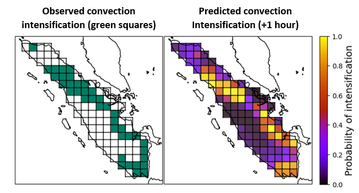
Left: Observed locations of intensifying convection (green boxes) over Sumatra, Indonesia. Right: SII-NowNet’s corresponding prediction of intensifying convection, with a +1 hour lead time.
PANCAST — Pan-African Convective Core Nowcasting with Deep Learning (Rakotomanga et al., in review)
PANCAST (Pan-African Core Nowcasting with Core-Aware Spatio-Temporal Transformers) is an object-based deep learning system for predicting convective core occurrence across Africa using geostationary satellite observations. It uses convective cores detected from Meteosat Second Generation (MSG) infrared imagery and models their interactions and temporal evolution with a spatio-temporal Transformer, producing gridded probabilistic nowcasts up to two hours ahead at 30-minute intervals. PANCAST is now live at https://pancast.io and will soon be available as a mobile application.
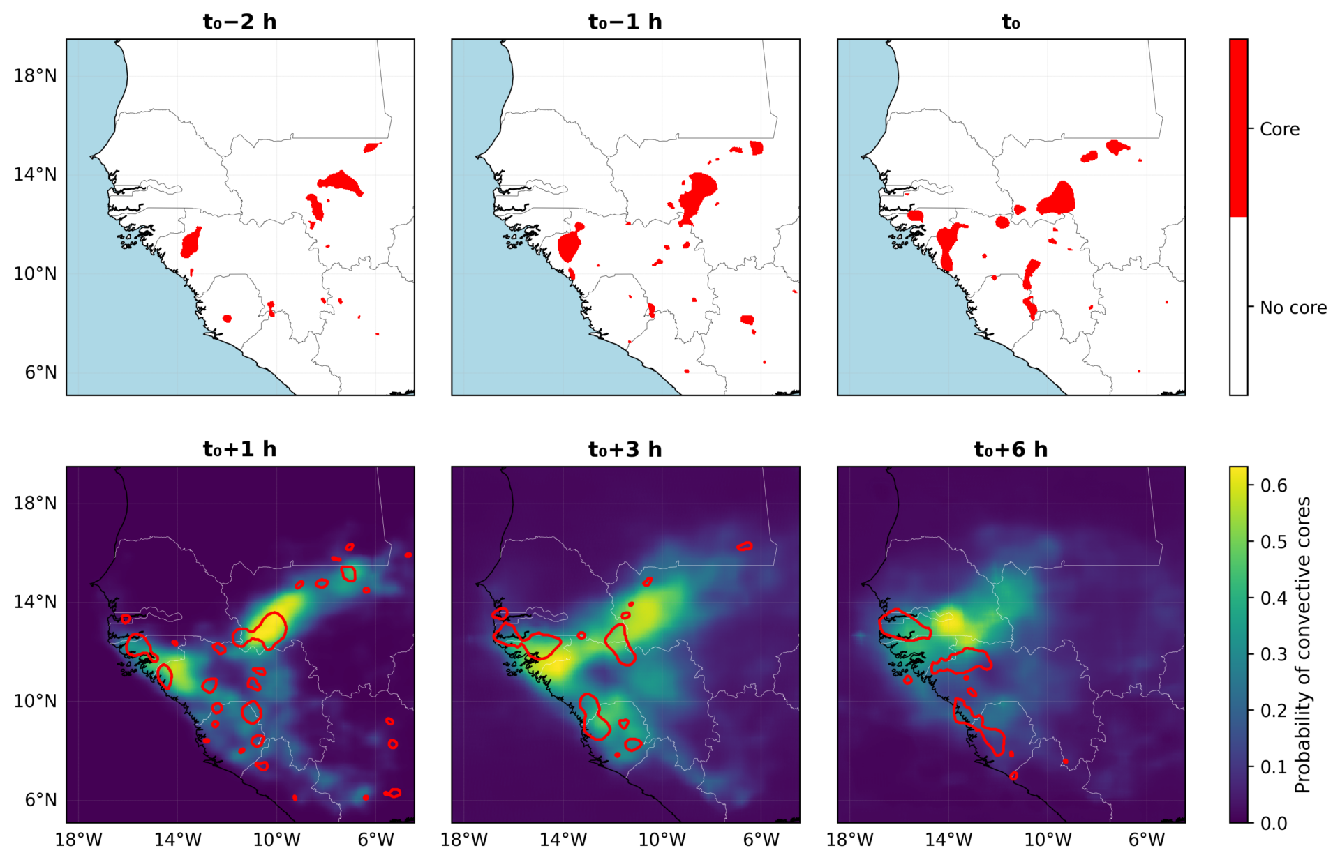
Example of a PANCAST forecast for a multi-core convective system over the western Sahel, initialised at t₀ = 27 September 2024, 17:15 UTC. Top row: observed convective cores (red) at t₀−2 h, t₀−1 h, and t₀. Bottom row: corresponding probabilistic forecasts at lead times t₀+1 h, t₀+3 h, and t₀+6 h.
Machine Learning for Short-Term Weather Forecasting for the Aviation Industry (Bartholomew et al., in prep)
Machine Learning for Short-Term Weather Forecasting for the Aviation Industry focuses on improving nowcasting of convection in the UK using machine learning techniques, with applications to aviation safety and efficiency. The research is centred on the London Terminal Manoeuvring Area (LTMA), one of the busiest sectors of airspace in the world. The work includes radar-based precipitation nowcasting using a variational autoencoder to generate ensemble predictions of future rain rates, as well as convection nowcasting using a UNet architecture with inputs from observations (satellite and radar) and Numerical Weather Prediction (NWP) model data to better represent atmospheric conditions relevant to convective development and decay.
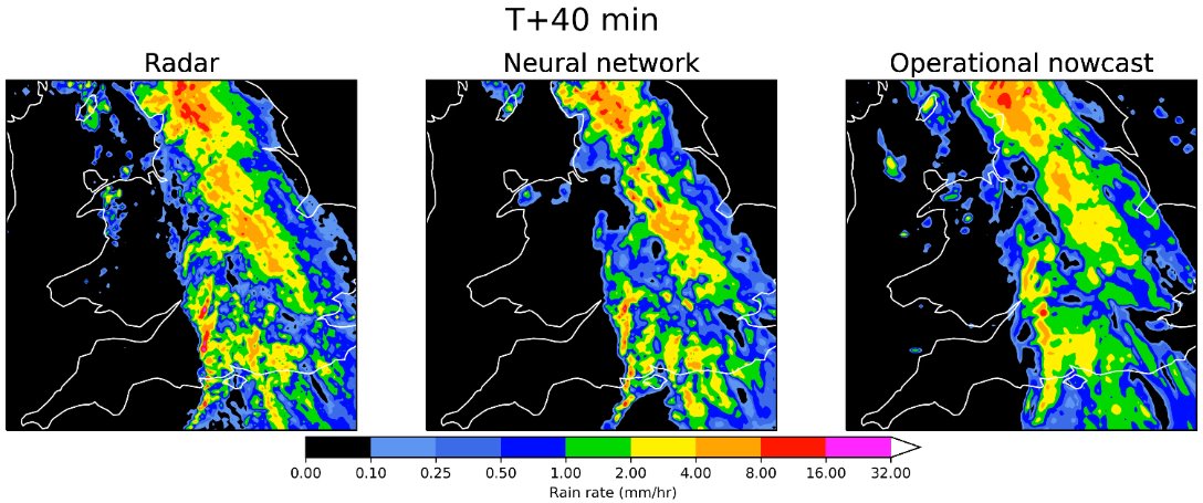
Radar-based precipitation nowcast with a variational autoencoder.

UNet-based convection nowcasting using satellite, radar, and Numerical Weather Prediction (NWP) data. Predicted vertically integrated liquid (VIL) fields are used as a proxy for convection.